Gps Acadia

Gps Acadia


Discovering and Mapping the lost trails and  history
Acadia National Park
Mount Desert Island

 Welcome.   This site contains gps data collected  in
the field using using historic trail maps, guides and
years of hiking in Acadia National Park


How it all started  still a work in process
 

Finding old printed maps of the area is very difficult. Those still around are in private collections and libraries.  There are however many maps available on line. The  Library of Congress has an in depth map collection.  http://memory.loc.gov/ammem/gmdhtml/nphtml/acadhome.html 

The most comprehensive work regarding the historic trails of MDI along with many of the old path maps and geological references can be found in a recent  publication by  the National Park Service U S Department of the Interior.


PATHMAKERS
Cultural Landscape Report for the Historic
Hiking Trail System of Mount Desert Island
History, Existing Conditions & Analysis 
ISBN 0-9779833-0-7.
Prepared by Olmsted Center for Landscape Preservation.
 

I have begun to retrace  the paths of the rusticators and early visitors to MDI using historic maps, guides, modern gps techniques and field skills  I am quietly rediscovering, documenting and  mapping the old trails and geological formations-curiosities  that are the history of MDI.

This all began as a training exercise on map scanning and calibration techniques. 
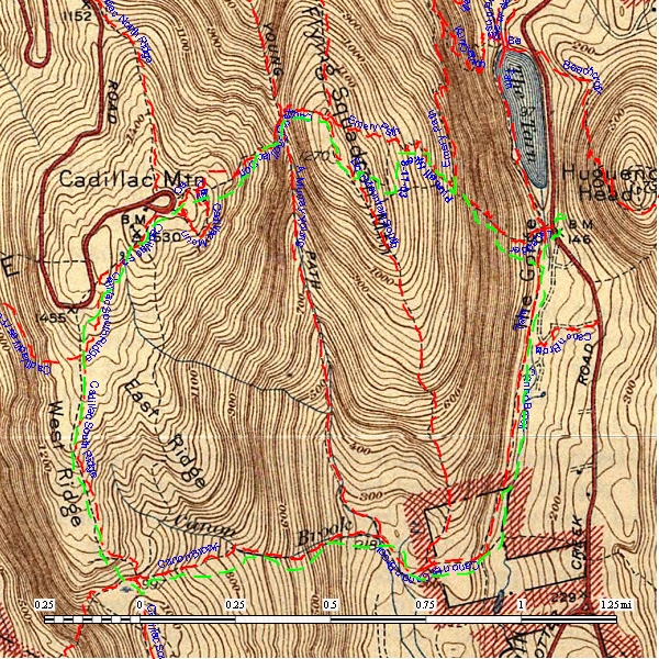
I scanned and calibrated  a 1942 topo map of Acadia National Park using  ExpertGPS .  If you click on the picture you will see that the data is the 1942 edition based on surveys done during the periods 1934-1935 and 1939.

Current  topo maps (1987 edition) refer back to this particular map and in many instances I believe the trails and markers were reproduced using the 1942 topo edition. 


Continuing the exercise I began creating  gps tracks and waypoints using data from the 1942 topo map that were no longer shown   Initially, I thought of my work with  old topo maps and modern gps software an interesting exercise and would not be of much use.

I have been pleasantly surprised. As  more time is spent in the field, the work I have done is  proving to be accurate and very rewarding.  With each  discovery (old moss and lichen covered cairns,  fallen trail posts,  paint marks, old stone stair cases, old road beds) I am getting a very modern day picture of the old trails and paths on the Island.


Scanned 1942 Topo Map showing trails and details of Cadillac Mtn Summit
with current gps track detail overlays


Scanned 1942 map showing trails and details of Cadillac Mountain Summit  with  NPS GPS Overlay of current maintained trails in Red.  GPS mapped hike done by my son in 2003 with an older Garmin GPS unit in Green.


Paths Less Taken

During the process of compiling and editing data I began having second thoughts over making the data readily available. Because of these concerns I approached the  Park Service asking what concerns they might have and provided them with preliminary data. Their response was articulate and confirmed my concerns.

The data provided here will not allow you to "load and go". Depending on your skills using gps, map, compass, field skills  and your desire to discover some of the history of Acadia the information provide here will start you on your journey.


Currently all files are in GPS Exchange format .gpx . You may download the file saving it to your computer. After opening the files in your gps program you should be able to select waypoints and tracks for uploading into your gps unit. 
Green Mountain Cog Rail
 
Day Mountain
Ox Hill
Tilting Rock
Caves
 
Eagle Lake
1800's House Foundation

 
Great Head Peninsula
moderate walk along sea cliffs Points Of Interest (POI) include remains of Satterlee Tea House,
sea cave, McKinney memorial  and triangulation station
download file here
Pothole Path
 
Pulpit Rocks
Pulpit 1,2 ,3 4


Trails tracks and waypoints
Updated July 15, 2010

Prepared and Maintained
Les H.
info@gpsacadia.com

copyright 1994-2010


This site is not associated with the United States Government,
the Department of the Interior or the National Park Service.